Olallie
 (technical difficulty)
 (physical difficulty)
Info
Stats
- 8.6 miles each way, plus a 2.5 mile pedal to the trail head via the John Wayne/Iron Horse trail.
- 2550 feet of vert, topping out at 3700 feet.
- 2/3 new singletrack, 1/3 road-trail conversion.
- $1.168 million project with funding secured by Washington State Parks.
- Construction team of DNR, Mountains to Sound Greenway and Evergreen.
- Construction is under way.
Big views, big vert, just outside North Bend
The trail starts near Rattlesnake Lake, just a few minutes outside of North Bend and only 40 minutes from Seattle.
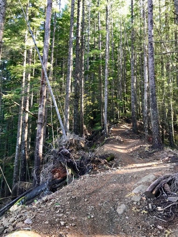
The first several miles amble up Cedar Butte through pristine forest, then turn east and ascend the flanks of Mt. Washington. As you climb, the sounds of I90 will slowly fade away. The tread is buff and non-technical, but don't let that deceive you into thinking the climb will be easy - although sculped to maximize ascent efficiency, the incline is relentless. The good news is that all translates to a virtually pedal-free blurred roller-coaster ride back down! This will require some care, as the trail is two-way.
At various points along the trail, you'll find stunning vistas from the marked viewpoints, some with a hand-hewn bench for getting a breath and a bite.
The trail then changes to road-trail conversion before climbing a rock cliff, but promises to be a stunning section of trail. The road-to-trail conversion is one of the best around, with undulations, camber and grade reversals, and naturalized vegation and rocks. There is a charming waterfall cascading down alongside the trail at one point.
The trail finishes on singletrack just below the summit of Mt. Washington.
Boxley Blowout historical site. The Olallie trail starts at Cedar Butte. Just to the SW of Cedar Butte is the site of the Boxley Blowout of 1918 and some interesting geographical features.

Photos


Videos
Ride Reports
A group of three of us, along with three or four other separate groups enjoyed the trail today while mother nature reloads for the next round of rain. The trail has drained really well so traction was good. However the leaves along the upper traverses are doing a good job at hiding the underlying...
Went up to the summit on this ride with my e-bike buddy and kept up as best I could. The vertical really drained his battery so he needed to turn around at the third viewpoint. I continued on to the summit and came back down. The trail is in great shape and the weather was cool and dry. I was in...
I saw EMBA rider tomvale's recent ride report, and had to climb up and check it out for myself. A few switchbacks past the first lookout, I spotted it! It's a great addition to the trail, and a fun point of interest. Thanks to tomvale for doing the research. Olallie has benefited from the recent...
Since the opening of the Olallie Trail, I always wondered why jets and aircraft always seemed to be flying overhead during my climb. There is no airport around but they fly over on a fairly frequent, periodic rate. 'NORMY' is not a term a wife uses for her husband in this case. 'NORMY' happens to...
It was a cool misty morning at 6am when I left the trailhead. Almost perfect climbing weather. There was a little drizzle that the forest kept from me until I got to the first Road to Trail conversion. Then the drizzle was gone but the foliage was wet when you brushed it. Visibility was a 1/4 to...
In my quest to keep you updated on snowlines, I ventured to Olallie to get back up to the summit of Mt. Washington. I began the climb just before 7am and no rain. The trail was hero, and the views were pretty and under overcast skies. I caught a bear wandering about 100 yards past the 'three stum...
The day broke calm,
And found dry hero dirt angled ever upward:
My heart, pounding.
Trail is basically perfect up to the ridge cross-over (the first section of road-to-trail conversion). Map says that's the first ~3.7 miles.
No snow at all on the first section of single-track, before the road-to-trail conversion. Once we hit the end of the first section of single-t...
Rode up to the second lookout this morning. It's a real grunt, some short steep sections and a ton of switchbacks. Nice and cool though, a bit misty. Blasted down, and great practice pre-turning to be able to carry speed through the switchbacks downhill. Super fun, wet but firm with occasio...
Olallie's a perfect morning ride! No crowds on a Thursday morning, nice and cool, damp but not wet and almost no braking bumps. I rode up to the second lookout, and loved the fast flow all the way down. Great trail for working on switchbacks. Also the bathrooms at the bottom are being maint...
We arrived at the Rattlesnake Lake parking late in the day. It was Panther's (2020 SantaCruz Megatower carbon CS) first bite of the trail and my second time to ride here. She was awesome and I felt more capable on this trail vs the last time with my very-old-but-strong Dori (2002 Specialized Endu...
Long uphill grunt and just before the third lookout my shifting completely goes to h*ll. Clanking and grinding, I bail to take a look and the rear derailleur is wedged into the cassette! Turns out my DT Swiss rear axle has come unscrewed, so I'm screwed. I walked back down a bit, upended the bike...
Three hours and 5,000' of climbing from the Rattlesnake Lake lot to the summit, where the fire road branches off. Admittedly, I pushed it through a few sections, I'm old! Descent was awesome, a little loose and rocky up top but smooth, bermed and amazing flow from the first lookout on down. Next...
Started early this morning from exit 38 in a light rain hoping for the mid-morning break when I got to the viewpoints. It didn't clear up too much at all so without the views to enjoy, I started cutting more trees out of the way. There are a few puddles from pine needle dams at the trail's low sp...
Went early starting at exit 38 and down the Iron Horse to Olallie and then climbed as high as I could until snow stopped me. There is still a need for the bigger saws at 2600' and beyond. There are a lot of trees down and some eroded hills higher that are dumping a lot of bigger rock on the trail...
Parked at Exit 38 since Cedar Falls access is restricted and rode the 4 miles of Iron Horse trail down to Olallie and began the climb. The trail is clear up to the converted double track and then, a half mile later, as you descend to the next viewpoints, shaded snow and a couple slide debri piles...
Olallie rode pretty well today. Not a single puddle or muddy patch anywhere along the trail (Raging River was VERY sloppy on 3/17). The section above the first overlook was a bit gravely, and had several twigs on the trail, but dry and snow free, at least until the flat spot prior to...
Friday was a nice cool day to get back in shape, as the limiting factor was my legs and lungs and not overheating. Two interesting cranky old man things happened on the trail: one was a trio of E-bikers who each said a minimum of 5 words or more to me; and two, the other two riders I saw on real...
Rode Ollalie for the first time on Sunday. Incredible weather for January. Blue skies in the mid 50's and no rain for the previous few days meant perfect trail conditions. A couple small patches of snow but the trail is clear all the way up.
The climb was "relentless" but manageable...
I ride this trail frequently. The snow starts at the makeshift campground clearing and was about a 1/4 inch. The lower half is clear and is main reason why most people ride it.
Cheers! and Merry Christmas!!!
Saw a cougar 0.4 miles from the parking lot on Iron Horse Trail. This was on the way back from Olallie trail head around 3:30p. Cougar saw me as I was riding towards him/her and it started to run away from me, then took a right turn into the forest. Trails were great today, nice and dry. A...
Started at the Cedar Falls trailhead and took a side trail to get to the iron horse for the 2 mile intro. I did Olallie about a year ago and my command post failed so I could not get all the way to the top comfortably. This time was different. I started the climb and kept going all the way to the...
Made it to the very end. About a mile and a half from the turnaround where nf-350 connects I had a close encounter with a large mountain goat who was not super excited about letting me by. Be aware Curred me of riding this trail solo.
Trail otherwise in spectacular shape, some...
We rode Olallie for the first time today and agree with KentKangley, great bottom, more work on top. We did not get to the end but made it to the only question mark on the route, which is the y where the uphill trail goes to Mt. Washington. You will pass several other Mt. Washington t...
It rained the whole way up. I rode 3/4 of the way to Mt. Washington crossing. The trail was very wet and had small puddles, which caused me to fall going uphill (In a small downhill section). Once you complete the switchbacks in the forest area, the trail was very smooth, little snow, should be m...
Snow at 3200' just after the campground. It's partially rideable, but would be an unpleasant uphill slog, so that's where I stopped and turned around. Otherwise, trail is in impeccable condition. Go for it!
Stopped by snow just past the campsite (7.3 miles from the parking lot, 3250' elevation).
Ran into unridable (soft and melting though) snow at 6.9 miles in (as measured from the parking lot); at a altitude of 3170 feet. A couple of trees across the trail. My guess is that it'll be snow free in perhaps a couple of weeks (early/mid May).
Olallie is riding well. A littlel loose in places with some blow down scattered around. Such a great climb!!! Snow starts at about 1400' but after this weekend it should be gone.
Try to keep foot OFF the gas on the last segment/section out of the trail. Hard to do since it'...
Trail is great for about 4.5 miles from the JWT. There were various patches of compact snow and ice all the way up to the viewpoint before the steep tight switchback section. I was lucky enough that the inversion brought temps upove freezing to make these areas rideable. Areas where the bike traf...
Olallie is holding up great, very little standing water or mud, no windfall, really good traction! Ran into snow at approx 2500ft.(6 miles away from Cedar Falls Trailhead) Turned around just past the double log bench viewpoint.
Got up to the trail early on a Friday morning, we had planned to go out and were determined to ride despite the weather. It was raining and in the mid 40s at the Rattlesnake Ridge parking lot.
The trail wasn't slippery even though it'd seen a lot of rain in the days prior - altho...
Sunny day - check. Perfect temp - check. Fall colors - check. Beautiful views - check. Hero dirt - check. All the boxes checked. Been riding since 1986 and today was the best. Not many warm sunny days left. Go get some.
I wasn't prepared for the sheer tranquility and breathtaking views of this trail, nor its virtually relentless ascent. It is an instant classic and a new personal favorite. The routing is expertly contoured to maximize pedaling efficiency over the buff, rolling switchbacks and through...
I rode the main Olallie trail to the camp (the flat pad above the second set of switchbacks shown on the annotated map) and then continued on as many others have done to the top of Mt WA.
Here are directions and a map for anyone who wants to give this a try. It was 22.3 miles and 5,...
Had a wonderful time on the new trail even with the hazy valley below. The incoming rain front was just crawling over Rattlesnake and then evaporating. It was an impressive transition into Fall. I only made it to the major switchback after the Mt Washinton trail junctions, and frustrations with a...
I rode as far as the Mt. Washington trail and did not see a closure sign. Does this mean it's open? It's fantastic. The Olallie trail is my new favorite ride. I ditched my bike partway up the Mt. Washington trail and hiked the last mile to the summit. Just below the...
Thanks to Shawn and the rest of the Evergreen MTB crew, and all of the volunteers who have been working on this new and soon-to-be opened trail. Please volunteer on Sundays so this trail can open timely. As an out-and-back trail, it's really a fun climb, and a cool downhill. The...