Blue Mountain Ridge
 (technical difficulty)
 (physical difficulty)
Info
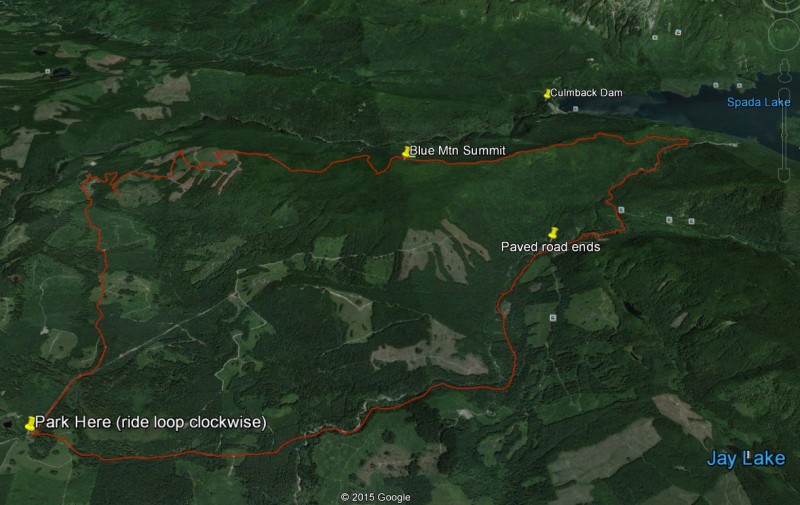
This ride is a logging road climb like Tiger or Rattlesnake (2500 vertical), a ridge line ride, and a downhill gravel, and then paved return road to your car. It is located north of Sultan, WA in the Snohomish county watershed southwest of Spada Lake. The west side of the ridge is a forested area where the clearings provide good view points.
Photos
Videos
Ride Reports
Today, I was looking to go to trails I’ve never been on but also try and explore the region around them if time permitted. While looking at the Trailforks reports for WA trails, the trails in th...
I went out to Sultan Basin Road this morning to go climb and traverse the ridge and also add an out-and-back to Upper Wallace Falls before getting back to the truck. I started climbing the west side and there was a decommissioned section of about a 1/4 mile that will grow over in a year or two so...
Parked at the DNR road and did the loop clockwise. The views of the valleys were great but the clouds were covering the higher peaks so Pilchuck wasn't clear. The lesson for today was 'don't get the Shingles vaccine a day before a rigorous activity or ride'. Had a physical yesterday and the doc s...
The full suspension bike is in the shop for a front brake overhaul so I took the gravel bike to Startup, WA and climbed the DNR roads off of Kellogg Lake Road to get up to the two Olney Falls, and Upper Wallace Falls. You first go by Lower Olney Falls, then continue climbing. After enduring a spu...
I sat worried about the muddy single track we have now and figured a long double track ride could be done until the trails dry out. I've been watching the fronts go by, dumping hail, and rain, along Highway 2 for the last couple of days and I tried to time the next "wave", like a surfer would, to...
Been in Florida for a family theme park tour and a trip to the Space Coast. I missed the delayed SpaceX launch so I needed to make up for that by getting back into some real topography. Also, my unofficial version of a COVID test, is a lot of miles or a lot of vertical, or both. I started with th...
Had a wonderful excursion ride below the snowline but high enough to get my vertical in. After the rains, I wanted to see the falls and the weather forecast was good. I parked just outside the DNR gate and began the climb and then made an attempt to ride up the Wallace River road but it is too ov...
Began early in the morning fog hoping the drier day would help the sun burn off the fog by the time I reached the ridge. I started climbing the west side of the ridge and took two spur roads to explore. One spur had a young bear that ran up hill quickly into the trees as my tires alerted it early...
Spent Saturday morning riding out to the Diversion Dam location on the Sultan River and enjoyed the river while relaxing in the peace and quiet of the canyon. The Diversion Dam Road is a 6 mile RT...
Went up from the west access and got up to the top of the Ridge's west side, 2900', but at the base of the hill to the tower, the road was still shaded and full of snow. I turned around at the snow and returned along the reservoir infrastructure and Sultan Basin Road. Timber work has been ongoing...
I actually rode to the peak just west of Haystack Mountain, just to the South of Sultan and the Blue Mountain Ridge but I can report that the recent warm fronts have washed the snows away below 3500'. I summited (4100') and there was only 6 inches up there. The climb west of Haystack was a...
Since the Blue Mtn loop is snowed in for the season, here is another twenty miler nearby you can do below the snowline and even ride to the top of Wallace Falls. The loop takes you to about 2000'. It is all logging road but you can hike the Greg Ball or Woody trail also if you want to do the fall...
Got out early at first light in between the snow falls. The road was bare until about 2700' when some trace accumulations began. The full loop was accomplished but the snows the rest of the weekend will probably shut down the loop unless we get a warm rain session. It is pretty up there. Track an...
Started early Sunday morning and started climbing with a goal of also trying to see the river valley. So during the climb of the western flank, I went down two side roads made for logging hoping to see a view of the river, or the watershed's diversion dam. Both attemps were a bust unless you want...
The road up is in great shape but there is active logging about a third of the way up the mountain on the main road so be careful. We reached the top but there is still some snow on the ground above 3,000 feet so we didn't complete the loop - returning back down the main road instead.
Started real early due to a break in the convergence zone so no rain or snow when I started. The road was clear until about 2400 feet when a trace was collecting. At 2800 feet I was riding in 5 inches of wet snow and the final climb to the tower would have been futile. Visibility was gettin...
Spent Black Friday outdoors climbing here before the first snows at 3000 feet cover the ridge and make it impassible. No mud. The tops of the 4000'+ peaks were dusted real pretty. I started a little late and rode the last half under lights. Toes were getting a little cold.
It was a wet and stormy ride today. I started around 7am with a Bob trailer now mounted to my 29r. Using the Robert Axle Project thru axle accessory, and Bob bobbins, along with the longer
Started in the early morning under lights and climbed to the top, across the ridge and then down to Olney Pass Kiosk, and then back to the car. Logging has pushed the road all the way across the ridge eliminating the heavy brush section to the tower. The logging road is well drained and of excell...
Spent the last two Saturdays riding the west side to the ridge line roads, and then by starting at Olney Pass and riding the ridge line to the tower. There is some timber development going on up there on top and the clear cutting has made a clearing to push the road all the way through. The clear...
First of all, thanks for posting this ride and the GPS info. It's always fun to have some new rides off the beaten path. Though this ride is never technical, the climb is challenging at times and rocketing down the twisty fire road on the descent was a lot of fun. I didn't see or hear another per...
Added another Highway 2 trail to the Evergreen site today after planning and riding it for the first time today. The ride starts at an access gate off of Sultan Basin Road and then after a mile, climbs into forested clearcuts and switch backs. There are nice views to the west and the top of Raini...