Icicle Ridge / 4th of July
Info
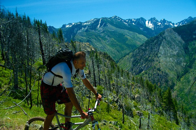
This route starts at the 4th of July trailhead, and climbs up 6200' to intersect icicle ridge trail, which leads to a 7455' descent. Incredible views and fun trail. If you leave your car at the 4th of July TH, you'll need to come back up on the paved road : (
There's a few different ways you can do this ride:
- climb up 4th of July, down Icicle Ridge. This loop involves 8 miles of paved road along icicle creek road, which could be shuttled out.
- Out and back up Icicle Creek.
- Up icicle creek, down 4th of July. Note the 4th of July TH is higher elevation, so this CCW loop will get you more climbing and less descent on singletrack, but makes the paved road section DH.
There are a few springs on 4th of July trail with good water. This trail is steep- mostly too steep to climb, but it does get the climbing over with minimal distance.
Navigating any of these routes is straightforward. At the intersection of 4th of July & Icicle Creek, consider taking the spur 0.2 mile to the 7029-foot former fire lookout site. There is no longer a structure here, but you can scramble up onto the foundation at 7029' to enjoy the view. East: Mission Ridge and the Entiat Range. North: Chelan Range, Glacier Peak, Poet Ridge, and the White Mountains. West: Icicle Ridge to Big Jim, Grindstone, and out to Daniel. South: Stuart Range and Cashmere. Icicle ridge trail west of this junction is not open to bikes.
Photos
Videos
Trail Status
Ride Reports
While passing through Leavenworth today I wanted to try the Icicle Ridge loop of the Forth of July climb and the Icicle Ridge descent. So I parked at the Icicle trailhead and headed up the road the 8 miles to climb Fourth of July. I got up about a third of the way and...
Pushed the bike most of the way. Even on the downhill, the corners are too sharp for a bike to go. Sides of the trail are loose, I fell twice.
There are better trails near the ski hill, https://cweverg...
This is such a great epic ride! Beautiful views, a good mix of flow and technical riding and you finish right in town. We encountered snow but still had a fun time and we were still able to ride everything. The trail is in good shape, which always surprises me given how little traffic there is up...
Took advantage of the beautiful fall weather last Saturday and found mostly good trail conditions. Here are a couple highlights: In the sub-alpine zone, the shrub (some kind of a mountain willow?) has gotten pretty thick and seriously encrouching on the trail at places - we had to carry our bikes...
A late summer storm put a few inches of snow on the the ridge so fire danger was low. Went up 4th of July and down the ridge to town. 2" of snow on the top 1000' of the ridge, but everything was rideable.
The climb is a grunt, but once up top the rolling ridge is in grea...
This ride is pretty dicey. Huge stretches of trail are currently unrideable.
The uphill from 4 th of July is a long trudge. Fire activity seems to have turned the entirety of the slope to loose scree and post-fire regrowth. The climb took 3-4 hours on foot, with c...