2015 Methow Singletrack Solstice Ride
Info
This ride, including the alternatives, was used in the 2015 Methow-Evergreen Singletrack Solstice Ride, our annual "club" ride and fundraiser.
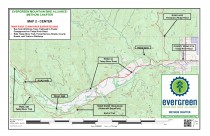
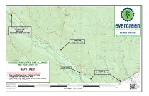
The point-to-point ride starts at the Poplar Flat Campground on the Twisp River Road, climbs briefly (1/4 mile) to the Twisp River Trail and then turns right (Southeast) to the Buttermilk Snowpark (10 miles). Then follow Forest Service Roads to the Twisp River Road (paved). Turn right on the Twisp River Road and go about XX miles to Bridge Creek (XX miles) Road (gravel, on left) and follow XX mile to Thompson Ridge Road. Follow this road XX miles and look for a closed road on the right, closed with earthen "tank traps". Follow this road and trail 2.1 miles and reconnect with Thompson Ridge Road. Follow the road another 0.5 miles to Goshawk/Woodpecker Trail (on right); you are now on the Sun Mountain Trail System. Use the posted map, Green Trails Map Sun Mountain #83S or Amazing Maps West Methow Trails for details on traversing this area and completing the ride to Winthrop.
Nearly all trail segments are on National Forest Service lands, wuth the exception of some trails at Sun Mountain the trails between Sun Mountain and Winthrop.
Photos
Videos
Ride Reports
The entire trail is in great shape. No fallen trees, substantial recent brushing, and nice tread.
Twenty riders were bused to the trailhead on Saturday and rode to Winthrop.

 (technical difficulty)
 (physical difficulty)


